Showing posts with label Sloe gin. Show all posts

Monday, 18 December 2023

Romney, Hythe & Dymchurch Railway sloe gin

The Romney, Hythe & Dymchurch Railway starts on the outskirts of the picturesque town of Hythe in Kent. Since the late-1920s, it has connected the historic Cinque Port with the smaller seaside towns of Dymchurch and New Romney and, eventually, the vast single split of Dungeness. 

Dubbed ‘the world’s smallest railway’, it leaves Hythe against a background of suburban back gardens belonging to flat-roofed terraced and semi-detached houses of the post-war prefabricated Orlit-type (pebbledashed cream and brown against the harsh seaside elements) and small-scale shops offering fishing tackle, traditional fish and chips and TV repairs. 

At first, the route roughly follows the A259, a long-distance coastal road that links Kent with Hampshire via Sussex. At Hythe, the Dymchurch Road section of the A259 snarls up with daytrippers on a sunny summer’s day, taking sun-lovers away from Hythe’s pebble beaches to the sandy vistas of Dymchurch and St Mary’s Bay. 
A quieter, slower route out of town for walkers, horse-riders and cyclists – punctuated only by the distinctive whistle of the steam train – runs either side of the Napoleonic-era Royal Military Canal, which reaches 28 miles into East Sussex, and runs roughly trackside until it hits the housing estates and bungalows of Burmarsh. Here, the train splits, striking out through flat, sparsely populated Romney Marsh. The bushes that overhang the canal on one side of the path, and separate the walker from the smoke of the train on the other, offer an abundance of blackberries and sloes in the summer and autumn months. The observant walker might also catch a glimpse of an exotic, curious animal or two from nearby Port Lympne zoo or the crumbling Roman remains of the Portus Lemanis fort, which sit beneath medieval Lympne Castle. 

Climb up onto ‘the Roughs’, the low-lying hills that flank the canal – today forming part of the Ministry of Defence’s estate – and dense undergrowth reveals a crumbling sound mirror, a remnant of experimental early 20th century technology designed to defend this stretch of coast against invaders. 
Although today the light railway mainly carries pleasure seekers and the occasional commuter – plus the all-important festive figure of Santa paying a visit at Christmas-time – it too once played an unlikely part in the Kent coast’s frontline defences. 

A typically jaunty Pathé newsreel of 1944, entitled ‘Toy Train Goes to War’, shows tourists replaced with soldiers aboard a special armoured train: during the Second World War, the light railway was taken over by the war effort and placed into the services of Operation PLUTO (Pipeline Under the Ocean), which sent fuel under the English Channel from Romney Marsh to support the allied forces in Normandy. PLUTO infrastructure was cleverly disguised as coastal bungalows; the remaining structures which are in residential use are now known as ‘PLUTO houses’, and are another historical curio of the quirky British seaside.

Sunday, 18 December 2022

Pilgrims Way damson gin

Thursday 15 September. The Queen is Dead and it’s day ten of national mourning. The weather is changing from summer into autumn and it feels like the mood – in fact the world – is changing, too, from an era of relative stability into an uncertain and unsettled future. There’s a chill to the wind and the sun is struggling to break through, only occasionally piercing the low, grey, moody Kentish skies to diffuse weakly outwards. I decide to set out from Hythe by bicycle to Wye crown, carved into the North Kent Downs high above Wye in 1902 to celebrate the coronation of King Edward VII, by students from the town’s agricultural college. I first spotted the giant crown from the train earlier in the year, en route from London to Margate, and was intrigued, wondering what on earth had made them to go all that effort. 
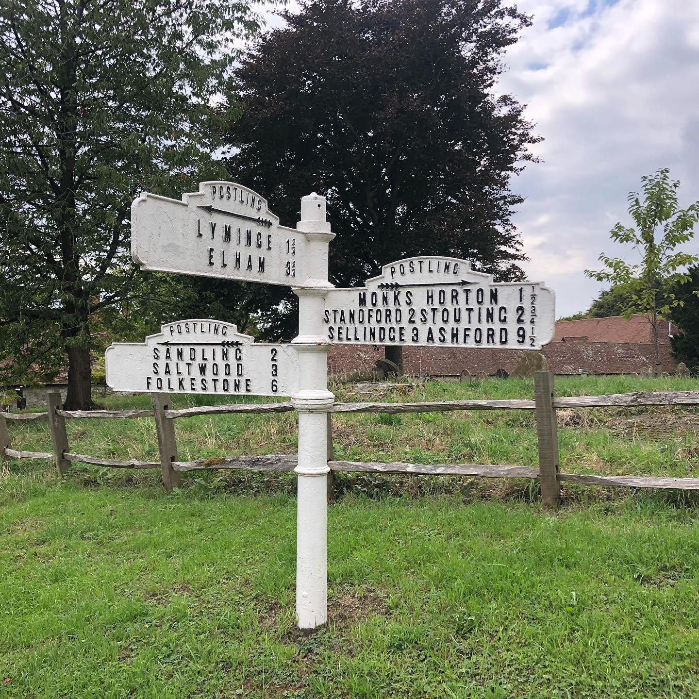
My route takes me uphill to Saltwood, where I get up close to a group of curious peacocks from the writer and broadcaster Kenneth Clark (and later, his right-wing politician son, Alan)’s castle, past the nursery where we used to go to pick out a Christmas tree every year from austere rows of pines, and over the M20 to Postling, a village that, while quite pretty, has no amenities except for a museum in a phone box. Joseph Conrad’s former home on the outskirts now has an airstrip outside, the fins of vintage planes peeking out of an old barn building. 
Soon afterwards, I pick up the Pilgrims Way, the route once taken to Thomas Becket’s shrine in Canterbury cathedral, which crosses Stone Street, the former Roman Road. The narrow road looks over the flat landscape below; marsh sheep and oast houses are now joined by vineyards and wind turbines. I pass homemade produce signs and honesty boxes closely monitored by CCTV and The Tiger Inn, advertising Mackeson’s Hythe Ales in large letters on its frontage. Damsons line the side of the road and apples rot in large back gardens; no-one’s picking them. As I struggle uphill, a couple overtake me on electric bikes. They have the right idea, I think to myself. 
As I reach Wye, I leave the road for an exposed, elevated footpath and the ground turns sandy and orange. The crown comes gradually into view, but the picture is partial and fragmented; close up it’s just a collection of white-painted rocks, enmeshed in wire. I follow a curve and try to picture the sections forming a crown in my head, then walk down the slope to see if I can get a better view. It’s impossible to see the whole from here – it’s best seen from the train line below, passing at speed, on the way to somewhere else.

Friday, 17 December 2021

Winter Hill sloe gin (Is this the way to San Marino?)

I had never been to Winter Hill – an open expanse of moorland above the large industrial town of Bolton – before. As a committed urbanite, I hadn’t walked up many hills of any scale. It wasn’t until the summer of 2021 that I finally fulfilled a long-held ambition of climbing Kinder Scout in the Peak District. I was inspired by a longstanding interest in the famous Kinder trespass of 1932, which pitted the rights of working people against private landowners who sought to deny them the freedom to roam in the open countryside that surrounded polluted, overcrowded towns and cities. When I heard about ‘Winter Hill 125’, therefore – a march to commemorate another successful and significant, but lesser-known, mass trespass – it seemed like the perfect excuse to get on the train to Bolton and take another walk. 
I didn’t expect it to be so far – or for this sunny Sunday in early September to be one of the last blazing hot days of the year. From the station, I walked alongside busy arterial roads to the start point of the march, a nondescript health centre a mile and a half out of Bolton town centre. Mingling with the crowd, I followed a colourful array of banners bearing socialist slogans and campaigning imagery, as the beats of the PCS union’s samba band buoyed us uphill through residential streets. Most of my fellow walkers seemed to know each other – and commented that I appeared to be the youngest on the walk by some distance! Many shared memories of taking part in similar commemorative walks, on previous anniversaries (including the centenary of the Winter Hill trespass in 1996). 

As we passed through different neighbourhoods, people turned out to wave: everyone, young and old, seemed pleased to see us. Heading towards the outskirts of the town, the houses changed in character, from dense redbrick terraces to mellow stone. Eventually, the roads narrowed to a country lane. I ate handfuls of blackberries from the side of the road, and picked a few sloes – a woman of South Asian heritage, curious, asked me what I was doing. 
As we left the town behind, the air began to clear and the samba band dispersed. For the first time, I stopped to look behind me, and saw the mass of people in the distance. There were hundreds – you don’t appreciate how many there are when you’re in the middle of it. I realised how high we were now, the town far below us. 
I kept walking. As we picked our way across the moors, over rough stones and clumps of grass, my footing became less steady. What should have been panoramic views of the surrounding landscapes were obscured by haze, and sheep and moorland was all that could be seen. Climbing higher and higher, I began to wonder where we were actually aiming for – and if we would ever reach ‘the top’. Eventually, six miles out of town, we seemed to come to a natural pause at a TV transmitter, a giant aerial stretching into the deep blue skies above, almost too tall to comprehend. 
Other walkers took out their sandwiches and made small talk with the Bolton Mountain Rescue team, parked up in a van. I wondered what going on. It turned out these were splinter groups, local rambling societies with plans to go in different directions and find their own routes across the moors. It appeared that I had, in my zeal, outpaced the rest of the organised march, and that we were now waiting for them to catch up. I felt truly as if I was in the middle of nowhere. It would be a long walk back down again and I began to panic, wondering how I would ever find my way back to the station. 
‘There’ll be buses from San Marino,’ I was repeatedly reassured. But what was San Marino? A little bit of southern Europe in windswept, post-industrial Lancashire? It seemed unlikely. Eventually, and gratefully, I was rescued by some friendly faces. Two former colleagues from my past working in the co-operative movement (which felt like a lifetime ago) appeared, who I hadn’t seen in years, and who lived nearby. 
We walked downhill together, a shorter and gentler route. San Marino was a Mediterranean restaurant in a picturesque spot overlooking a reservoir (one of many in the area, originally built in the Victorian era to service Bolton’s growing industries). There, we were met by local buses, which took us back to the town centre free of charge. The short journey back to town wasn’t just a welcome opportunity to rest my legs, but to catch up with others on the walk, find common ground and connections, and share stories. Winter Hill had brought us together.

Saturday, 14 December 2019

Hythe ranges sloe gin

The deep pink promenade stops abruptly at Fisherman’s Beach and doesn’t resume again until the redoubt fort at Dymchurch.
The stretch of beach between Hythe and Dymchurch is accessible only from Ministry of Defence land, via a muddy, stony path that skirts Hythe Ranges. It follows the curve of the fast-moving main road yet is separated from it by the thin facades of a fake village: shops and houses exist only as moving targets on tracks. Artificial hills of sand carry huge numbers, which look strange against the sky. Rabbits have burrowed into the slopes among bullet cases. The real town of Hythe rises on the real hills in the distance: peals ring out faintly from Tuesday night bell-ringing practice at St Leonard’s Church, half-way up.
Whilst the rest of the coastline has become built up – even the fishermen’s huts that give Hythe’s most picturesque and characterful beach its name are now outbulked by luxury apartment blocks – the only real buildings on Hythe ranges are abandoned and half-submerged Second World War pillboxes, their entrances silted up with shingle, and Napoleonic Martello towers, built to withstand a much earlier threat of invasion. Accessible only to pigeons, one has crumbled half into the sea, its brick innards exposed, spiralling out onto the beach in Lego-like chunks. More recently, defensive infrastructure has taken on the sea – wooden planks shore up the banks and waves crash against stacks of rock as cormorants stretch their wings on sewage pipelines.
The bay curls around the corner towards the blocky outline of Dungeness Power Station in the distance. The shingle expanse of Dungeness is apparently the UK’s only desert. It’s not unlike that here. What grows must be able to withstand the exposure of the wind, the salt and the sea: prickly gorse, rubbery sea kale, one wild pear tree. Small, hard blackberries ripen yet never quite lose their sourness and low-lying blackthorn bushes, fruited with sporadic sloes, cling to the ground.
Sand is only revealed at exceptionally low tide, when fishermen with buckets scour the muddy flats for lug worms to use for bait. For years you saw few people here other than fishermen, out in rain, shine and even on Christmas day, huddled in tents, their backs to the wind and only their headlamps shining through the gloom.
Now there are people out with matching gloves and buckets, foraging in a systematic way: samphire? This place doesn’t feel so wild any more.

Saturday, 15 December 2018

Folkestone Warren sloe gin

Fight your way through tangles of brambles, nettles and blackthorn bushes, and keep your footing on the narrow, uneven paths that lead down to Folkestone’s Warren, and you’re rewarded with access to the town’s most attractive beach.

The Warren is a bay at the foot of the white cliffs, looking across to the low-lying coast of France on a clear day. Despite being geographically close, it feels a world away from the Folkestone’s most popular beach, Sunny Sands, where the raw bodied and raw faced holiday people observed in Ted Hughes’ poem Work and Play

Are laid out like wounded
Flat as in ovens
Roasting and basting
With faces of torment as space burns them blue.

Although out of town, the Warren is well worth the trip. As part of an exposed coastal landscape that has been remade by landslips over the years, the cliffs are shored up by a wide concrete apron constructed after the Second World War. When the tide is right, regular rows of concrete groynes create the impression of a series of private beaches, both separated from the promenade above and cut off by gently lapping waves to the side. At low tide, the concrete is coated in a springy carpet of vivid green moss that’s treacherous under foot. At high tide, fishermen cast their rods out to sea and concrete steps provide the perfect entry point for swimming in the English Channel, which turns a Mediterranean turquoise under the summer sun. In winter, when stormy grey waves slap unpredictably against the edge, it’s wise to keep your distance.
Although the Warren is home to a small campsite – and the occasional illicit camper and hermit residing in shacks built into the cliffs – it’s mercifully free of crowds. It’s overlooked only by a couple of Martello Towers, a lone clifftop café at Capel-le-Ferne and a clifftop artwork, Siren, by Marc Schmitz and Dolgor Ser-Od, inspired by the improbable early twentieth-century wartime technology of concrete listening ears, and installed as part of the 2017 Folkestone Triennial.

It wasn’t always this way. The Warren, which had a reputation as Folkestone’s ‘Little Switzerland’, was once a destination for daytrippers and pleasure seekers, served by its own train station.

The Warren is separated from touristy Sunny Sands by an expanse of rocks, popular with fossil hunters. Sifting idly through the beach’s mixture of sand and pebbles reveals its own treasures, though: pebbles made from brick in various shades of red and yellow, worn smooth over the years, and translucent, gem-like ‘sea glass’, delicately frosted ovals of white, green, brown and blue glass created from decades of discarded bottles being thrown around and ground down by the tide.

Follow the cliffs in the other direction, past Abbot’s Cliff nudist beach, and eventually you’ll reach the port of Dover. The Folkestone to Dover trainline, too, takes this route, through the cliffs and past the Warren. Though short, it’s a dramatic ride, as the train emerges suddenly alongside the sea. Although spectacular, the route has its perils. In December 2015, storm damage closed the trainline for a full nine months, a reminder that the conceit of man’s control over our island coastline is illusory at best, and that its shape, form and the nature of our relationship with it is something we should never take for granted.

Friday, 15 December 2017

Fallowfield Loop damson gin

In the 1960s, Dr Beeching paved the way for the reduction of the British rail network, closing small village stations and branch lines and catalysing the ascendancy of the motorcar as the dominant mode of transport in Britain*.

Some of long-closed lines are now reopening, after decades dormant. Others, their tracks removed permanently and their station buildings now converted into shops and supermarket cafes (as is the case with the former suburban Manchester stations of Levenshulme and Fallowfield), offer cyclists miles of dedicated bike path free from the traffic and aggressive motoring that increasingly chokes our towns and cities.

Manchester’s Fallowfield Loop stretches around eight miles, looping around the south and east of the city. Beginning in inner-city Openshaw in east Manchester and ending in leafy Chorlton in south Manchester, it undulates through the former industrial dormitories of Gorton and Levenshulme, passes picturesque Debdale Reservoir, skirts the boundary of Stockport at Reddish, and cuts through studenty Fallowfield and leafy Whalley Range.
The Loop has the feel of a linear park, offering a backdoor view of the city and its patchwork of official and unofficial green spaces. The Loop itself is an underacknowledged green space. In spring and summer it’s overgrown with branches forming a green tunnel, although in autumn the slipperiness of the accumulated layers of leaves can be treacherous. In winter, the foliage drops right back to reveal numerous back gardens, allotments, recreation grounds, school playing fields, overgrown brownfield sites and industrial land reclaimed as country parks. It links up with other traffic-free routes, too, from the Ashton Canal, with its miles of recently resurfaced towpath, to former branch canals such as the Stockport canal.
The Fallowfield Loop has become a place of community activism and communal litter-picks. It’s also a place of memorial, to young people who have killed themselves. Recently, it’s become a site of protest, with large EU flags unfurled unmissably from road and railway bridges; when removed, they reappear again soon afterwards, imported en masse from China. Pro-EU graffiti sprayed along the path places the UK at the heart of the EU, and the Manchester bee motif is placed centrally within the circle of stars that represent the EU member states; it’s a reminder that Manchester, along with the neighbouring local authorities of Stockport and Trafford, which the Loop passes close-by, voted remain in the EU referendum, in common with several other northern cities. It’s also a place for creativity, from street art murals celebrating the city’s architecture, to hand-written personal declarations (and accusations – ‘Louis K has a tiny penis’). It’s a place to encounter culture, from bicycle theatre troupes offering outdoor Shakespeare performances to public artworks sponsored by the cycle charity Sustrans, which document and draw attention to the flora and fauna of the route. It’s a place of learning and instruction, for small children to gain confidence and practise their bike skills away from the road. It’s also a place for family time: on father’s day, it’s noticeable how the number of men with small children increases.
Not all is benign – once or twice a year the ambush of women or opportunistic robberies make the deadlines, and mounted police undertake regular patrols. However, generally it’s a place of conviviality and sharing: if a cyclist stops at the side of the path, the next to pass will stop to see if all’s okay, and offer help fixing a chain or a spare inner tube.

Although cyclists benefit the most from a safe cycling environment uninterrupted by the frequent stops and starts of traffic lights, the Fallowfield Loop is also well-used by walkers, joggers, dogwalkers, students, and schoolchildren on their way to and from school, as well as shoppers just getting from A to B. It’s a meeting place, too, particularly for groups of teenagers.
These looplines are also fruitful places for the urban forager. Depending on the season, edible mushrooms, horseradish, strawberries, raspberries, cherries, plums, damsons, sloes and apples can all be found along the Loop, whilst in late-summer individuals and groups of people of all ages gather with an assortment of receptacles, from large yoghurt tubs to seaside buckets, Tupperware tubs and carrier bags, to gather blackberries, and offer hints on the best spots.

This year’s damsons were picked along the Fallowfield Loop, in a year that was unusually fallow for apples, yet plums and damsons of varying hues were in abundance.

* For a more detailed account of cuts to train services in Manchester see https://mancunian1001.wordpress.com/2013/03/26/the-reshaping-of-our-railways-1-before-beeching.

Wednesday, 7 December 2016

Sugarloaf Hill sloe gin

The hills of the Folkestone downs – Sugarloaf Hill, Castle Hill, Hoywell, Cheriton Hill and Round Hill – rise out of the gently undulating Kent countryside like green bowling balls, left by some giant en route to the channel. If they were to crouch down, survey their target, flex their arm and roll them across the flat landscape they’d hit the cliff-top town of Folkestone, which diffuses out from the sea in dense avenues of former redbrick mansion blocks and neat semis, rarely letting up to allow in parks or open spaces.
From a distance, the blueness of English Channel intensifies. The steps of an ancient earthwork ripple like the sea below; a more contemporary artwork, the white horse of Invicta, spreads out across the downs. It’s Folkestone’s answer to the Hollywood sign, a bit of modern-day branding for a town which has for many years seemed relegated to a comfort break on the side of a motorway, a stop on the train line between the coast and the capital. Folkestone was hit hard by the twentieth century decline of domestic tourism and the closure of its ferry and hovercraft links.
From up on Sugarloaf Hill the town’s former grandeur as a tourist destination is apparent in a way it might not be at street level. The Grand and the Metropole hotels are lumbering redbrick footprints teetering at the edge of the cliff like non-identical twins. The high-rise offices of the town’s newspaper, the Herald, rise above the empty shops of the town centre. The premises of an insurer that’s long since left town – now a curry house – offer a rare bit of streamlined modernist glamour. A tall Victorian railway viaduct tiptoes across terraced houses, bringing daytrippers in and connecting commuters with better-paid, higher status employment outside. Up high are wartime ditches built to defend the south coast. Below, two Martello towers represent an earlier era of threatened invasion, one pristine, one overgrown. Close up, the town becomes more anonymous, a familiar scene of grey out-of-town retail sheds and the teen haunts of drive-thru fast food joints. Then, the landscape begins to empty out, towards the eerie remoteness of Romney Marsh and Dungeness in the distance.
Straight ahead, the French coastline hides behind a hanging mist or smog, but it’s only a train ride away: Eurostar speeds past, trains and wires sloping across the countryside. Trains no longer stop at the Folkestone Harbour train station, stretching out into the sea like a tentacle feeling its way to the continent, but visitors are now greeted by a text work by Ian Hamilton Finlay at the end of the harbour arm, a legacy of the Folkestone Triennial’s attempts to reinvent and inject some poetry back into the town.
Sugarloaf Hill and its neighbouring rotundas feel like the countryside, but it’s an illusion. Highway cattle roam woods and scrubland, fields of wheat, hay and wild marjoram, and thick passageways of blackthorn bushes, but the motorway's hum is hard to ignore. We pass through these hills in polluting metal boxes – an A-road on stilts goes in at Folkestone and comes out at Dover – and drink its water, from hidden reservoirs. In summer, runners puff up and down and young lovers picnic in relative privacy. Sugarloaf Hill is both of the town and a place to escape from it, to watch it from a distance, to bring a bit back with us, as sloes to mix with sugar for winter sloe gin.

Saturday, 17 December 2011

Three litres of sloe gin, or a tale of two blackthorn bushes

This sloe gin started life in late-summer 2011 as ripe sloes gathered from two blackthorn bushes: one on the banks of the Ashton Canal, Ancoats and one by the River Sett between New Mills and Hayfield in the Peak District.

The Ashton Canal winds its way from central Manchester to the market town of Ashton-under-Lyne, six miles to the east. It's a remarkable journey that takes walkers, cyclists, boats and geese past the boom and bust regeneration of inner-city Manchester (half rebuilt and reinvented as New Islington, half still rubble and spaces left by ruined mills and factories); alongside Manchester City Football Club's glittering stadium and the slightly less glamorous Eastlands retail park (highlight – ASDA); near the shabby Victorian elegance of Philips Park, Manchester's first public park, leading to reclaimed nature reserve Clayton Vale and the Medlock Valley; and next to Fairfield Moravian Settlement, an island of tranquil cobblestones and Georgian cottages surrounded by suburban Tameside with its canal-side sports pitches and pensioners playing waterside pétanque.

We are lucky to have this urban oasis running through the city: the canal would have been closed in the 1960s if the local council had its way. When road transport became widespread, canals went out of fashion. They grew obsolete and expensive to maintain – and it took volunteers across the country long and laborious hours to restore Britain's canal network. These campaigners reimagined a new use for the inland waterways as sites of leisure and tourism – for boating holidays and afternoon walks – rather than toil – horses and boats still hauled coal and other goods along canals, including the Ashton, well into the twentieth century, the purpose for which they had been built centuries before. At Ashton-under-Lyne, the Ashton Canal hits the Portland Basin (home to the Wooden Canal Boat Society and Portland Basin Museum), where canal adventurers head south east onto the Peak Forest Canal to continue their journey through the Cheshire towns of Hyde and Marple and then on to New Mills (a place defined by its spectacular geography; the town rises up into the hills as the rivers Sett and Goyt descend into sunken Torrs below) and Whaley Bridge in Derbyshire, where the canal comes to an end.

The second blackthorn bush was encountered along the Sett Valley Trail between New Mills and Hayfield on a rainy yet peaceful bank holiday weekend walk. Hayfield is a picturesque rural village overlooked by the Peak District National Park's highest point, Kinder Scout – a landmark visible back in the city, from Ancoats, where this story starts. In April 1932, Kinder was the scene of one of Britain's most famous protests. Several hundred ramblers from Manchester and the surrounding region, including folk singer Ewan MacColl, led a mass trespass up Kinder Scout to protest that what had previously been common land had been taken over by private interests. It's them we must thank for our rights to roam over Britain's countryside today, something we can take for granted: the ability to explore and reach out from the crowded cities around us, to wander at our leisure.

2012 will be the 80th anniversary of the Kinder Trespass. Find out more at http://kindertrespass.com or visit Salford's Working Class Movement Library, which holds material related to the protest.

The Golden Age of Canals, an excellent BBC4 programme about the formation of the Inland Waterways, mass activism to save canals and their changing uses, will be repeated on Monday at 7pm.

Friday, 3 December 2010

The Shrieking Violet and Manchester Modernist Society joint event — Newspapers on Film, Saturday December 11


Newspapers on film

Saturday 11th December, 3.30pm-6.30pm

Manchester Modernist Society HQ, 142 Chapel Street, Salford M3 6AF

Free

The Shrieking Violet fanzine and Manchester Modernist Society invite you to a seasonal gathering celebrating Manchester's media heritage through documentaries from the North West Film Archive.

There will also be some baked goods from recipes which have appeared in past issues of the Shrieking Violet fanzine expect shortbread, sloe gin, grape vodka, tea and an edible, highly glittered Daily Express building.

Showing

People and Places Around Ordsall

Salford newsagent, amateur filmmaker and onetime newspaper delivery boy Ralph Brookes documented the changing face of the inner city area Ordsall in the 1960s and ‘70s, making over ninety home movies about the community around him, documenting everything from his home, family, birthdays and Christmas to mingling with the stars for an episode of Coronation Street which was filmed in the local park.

Here is the News

Colourful, jaunty, jazz-soundtracked film about how the Evening News is produced. Made in 1968 to celebrate the newspaper's centenary, the film shows the 'daily miracle' that is producing a newspaper, from visiting the various departments in the newspaper offices to distributing copies around the city to be read in suburban family homes.

News Story

A day in the life of the famous Guardian newspaper in 1960 (four years before it moved to London), from meeting the journalists in the various departments which put it together to printing with linotype and hot lead and its distribution around the country.

The event accompanies a media themed special of Manchester-based fanzine The Shrieking Violet which looks at various aspects of Manchester and the media including Jack Hale of Manchester Modernist Society writing in praise of the innovative Daily Express building on Great Ancoats Street. The films in the North West film archive help give a sense not just of the labour and space intensive process that traditionally went into making newspapers, pre-digitisation, and the buildings in which they were made, but also illustrate the importance of newspapers in the city. The films, which each last around twenty minutes, provide fascinating insights into the time in which they were made: Here is the News is an optimistic look at the modernist city in the swinging sixties, whereas People and Places in Ordsall depicts the other side of life in the region, and the great changes Salford was undergoing at the time as part of slum clearance programmes.

Poster by Lauren Velvick.

www.manchestermodernistsociety.org/

Here's the edible Express Building — shortbread topped with readymade black icing from the Arndale Market, into which was embedded many silver balls. Sprinkled with black edible glitter.

Thursday, 25 November 2010

Sloe Gin

This week, coinciding with the start of the freezing weather, I had the first taste of my sloe gin, which has been steeping for ten and a half weeks. Although it's a bit early, I wanted to bottle a small quantity to give to a friend for her birthday this week. It's a deep red colour, almost opaque, that glows warmly when you hold it up to the light. The consistency is smooth and glossy, thicker than gin, and there are two distinct tastes intensely bitter (perhaps because of the gin, or maybe because I picked the sloes early in autumn before they'd had chance to sweeten) and very sweet but with an overall fruitiness. It's so rich it invites being savoured in tiny quantities. I looked all over for the perfect bottles, considering some ornamental Vom Fass bottles from the Selfridges food hall, but it wasn't possible to buy bottles without the oil and I didn't want the problem of what to do with the oil. In the end, I bought a 250ml bottle of Devon apple juice from the chiller cabinet as it had a screw top, drank the juice, sterilised the bottle and came up with a colour co-ordinated, vaguely icicle themed label. The rest of my sloe gin has gone back in the cupboard to steep some more before I get it out again properly in December.